From the journal

The Canal Between Two Great River Basins

At Lingqu in Xing’an County, overflow weirs, divided channels and curved reaches connect the Xiang and Li river systems.

In the same city · Guilin ↗
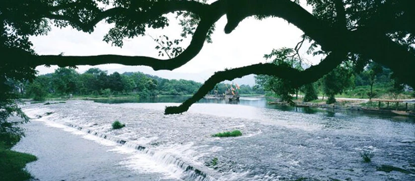
Water spills over a broad low weir beneath spreading tree branches at Lingqu.
A low overflow weir at Lingqu, with a broad crest and shallow fall, pictured on the official Li River scenic-area website.

A small crossing with a very large map

Lingqu makes sense as a link between two drainage basins. The Xiang belongs to the Yangtze system; the Li belongs to the Pearl River system. Their upper waters approach one another around Xing’an, within Guilin’s wider jurisdiction. Connecting them required a navigable route across a watershed, not simply improvements to an existing stretch of river.

China’s submission to UNESCO’s Tentative List describes a canal-head complex and northern and southern channels. The waterway is roughly 36 kilometres long, small beside the river systems it connects. Its importance is disproportionate to its apparent size: a short engineered link changed the usefulness of a much larger network.

Raise, divide and release

At the headworks, the da tianping and xiao tianping are overflow weirs associated with the huazui, a guiding and dividing structure. Their tasks are related but distinct. Raising the upstream level makes diversion possible; directing the flow sends water toward the channels; overflow and discharge help manage excess water.

A water-resources bureau account describes the northern channel returning to the Xiang and the southern channel reaching the Li system through artificial and improved natural waterways. The two directions tie the headworks to different river systems. Water engineering operates under changing conditions. The approach of water, its passage around the structures and its route onward make the engineering visible even when the surface is quiet.

Why the longer route can be the better route

A canal designed for boats must consider water depth and speed, not only the shortest distance between two points. Lingqu’s curved reaches lengthen the distance over which a change in level occurs, helping moderate the gradient. The scenic meander also expresses a navigational decision.

The canal’s water-control facilities, known as doumen, are discussed in engineering research in relation to low-water conditions. These arrangements evolved over the canal’s long history and differ from standardised modern lock chambers. The route’s bends and controls made water and passage manageable across changing levels.

The Qin idea survives through later work

Lingqu’s conventional completion date is 214 BCE, but that does not date every visible stone. The 2013 Tentative List submission states that important surviving features generally retain forms associated with the Qing dynasty and the Republic of China. Repairs and alterations belong to the canal’s history of use.

A working canal had to be repaired after damage, adjusted as needs changed and kept clear enough to carry water. Replacing material could sustain an old hydraulic relationship rather than erase it. The early origin and later surviving structures are both part of the canal’s long history of repeated care.

A heritage waterway still needs clean water

A 2025 Ministry of Ecology and Environment account describes earlier pollution and declining flow, followed by sewage management, channel repairs, ecological restoration and supplemental water supply. It also reports restored navigation along a section of the South Canal. That account updates older descriptions of the whole system as no longer navigable.

Managing water for several purposes remains central to Lingqu. A restored bank alone cannot resolve pollution coming from beyond the view. The canal remains on China’s UNESCO Tentative List, a proposal-stage designation distinct from World Heritage inscription and from the inscribed Grand Canal property. Its waterworks and continuing role are central to its significance.

Continue exploring · Lingqu Canal ↗
Photo credits and rights
  1. A low overflow weir at Lingqu, pictured on the official Li River scenic-area website. Its broad crest and shallow fall make water-level control visible. The photograph does not show the whole canal network or establish the age of the masonry now seen. Capture date unconfirmed.Guilin Li River Scenic Area official website; photographer not stated · Rights information Photo source ↗ Resized and converted to WebP; full composition retained.